
Business Details
50 Years
experience
Expert Land Surveying and Civil Engineering Services in Buffalo, NY
Founded in 1976, our firm has built a legacy of excellence in civil engineering and land surveying across Western New York. We specialize in boundary surveys, topographic mapping, and construction stakeouts, serving engineers, architects, attorneys, and contractors. Our team combines decades of experience with cutting-edge technology to deliver precise, compliant solutions for projects of all scales. As a certified Woman Business Enterprise (WBE) and Disadvantaged Business Enterprise (DBE), we prioritize diversity and technical expertise. Our staff includes licensed professionals with extensive experience on major regional projects, ensuring accuracy and reliability.We maintain rigorous quality control through licensed supervision and advanced data collection tools. Our commitment to innovation and client satisfaction has earned recognition from industry organizations. We work closely with clients to meet deadlines and budgets while adhering to strict regulatory standards. Our historical expertise traces back to the records of Deborah A. Naybor, Professional Land Surveyor, PC. Today, we continue to uphold the values established by our founder, Philip F. Frandina, who shaped the engineering community for decades.
Services
Boundary Surveys
Topographic Surveys
Construction Stake-Out
As-Built Surveys
Highway Design Surveys
Airport Design Surveys
FEMA Flood Certificates
Details
- Year established: 1976
Highlights and features
- We offer over 45 years of combined experience in civil engineering and land surveying.
- Our firm is certified as a Woman Business Enterprise (WBE) and Disadvantaged Business Enterprise (DBE).
- We utilize advanced AutoCAD and GPS technology for accurate data collection.
- Our team includes licensed professionals with expertise on major regional infrastructure projects.
- We maintain strict compliance with state and federal regulations for all surveying work.
Associations and certifications
- WBE
- DBE
Services
Boundary Surveys
Our boundary surveys establish precise property lines using historical records and modern GPS technology. Licensed surveyors analyze legal documents and conduct field measurements to resolve disputes and support real estate transactions. Clients receive detailed AutoCAD drawings for regulatory compliance and construction planning.
Topographic Surveys
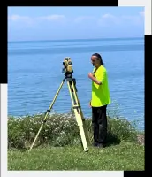
We create detailed topographic maps showing natural and man-made features for engineering and development projects. Our surveys capture elevation data, vegetation, and infrastructure to support site planning and drainage analysis. Field crews use robotic total stations and GPS systems for high accuracy.
Construction Stake-Out
Our construction stake-out services ensure accurate implementation of engineering plans through precise field markings. Surveyors establish reference points for foundations, utilities, and roadways using digital data from design documents. This service maintains alignment and grading specifications during project execution.
Highway Design Surveys
We provide comprehensive surveys for highway and roadway projects including alignment, right-of-way, and drainage assessments. Our data supports pavement design and traffic flow analysis. Surveys comply with NYSDOT standards for municipal and state transportation infrastructure projects.
FEMA Flood Certificates
Our certified professionals prepare FEMA flood certificates to determine property flood zones for insurance requirements. Surveys include elevation data relative to floodplain boundaries. We provide Letter of Map Amendment (LOMA) documentation to challenge inaccurate flood designations.
People
Rosanne Frandina
President & Project Manager
Licensed Professional Engineer and Land Surveyor with expertise in project management and regulatory compliance. Oversees survey and engineering coordination for major infrastructure projects in Western New York.
Mark Childs
Professional Land Surveyor
NYS licensed surveyor with 40+ years of experience in field surveying and AutoCAD mapping. Specializes in large-scale infrastructure projects including airports and medical facilities across Western New York.
Corey Mitchell
Survey Crew Chief
Certified OSHA 10-hour and HAZWOPER 24-hour safety trainer with 30+ years of field survey experience. Manages data collection for boundary, topographic, and construction surveys on complex projects.
Eric Zimmerman
Survey Instrument Operator
Certified surveyor with 20+ years of experience in GPS and hydraulic surveying. Specializes in precise data collection for construction layout and topographic mapping projects across Western New York.
Questions
What surveying services do you offer?
We provide boundary surveys, topographic mapping, construction stake-outs, highway design surveys, airport surveys, and FEMA flood certificates for public and private sector clients.
Are you certified as a WBE/DBE firm?
Yes, we are certified as both a Woman Business Enterprise (WBE) and Disadvantaged Business Enterprise (DBE) with New York State and local agencies.
What areas do you serve?
We operate throughout Western New York, including Buffalo, Erie County, and Niagara Frontier Transportation Authority projects.
How do you ensure survey accuracy?
Our licensed professionals use robotic total stations, GPS systems, and AutoCAD software to maintain precision within industry standards for all survey types.
Can you handle large infrastructure projects?
Our team has experience with major projects including Buffalo Niagara Airport, Erie County Medical Center, and State University Construction Fund developments.